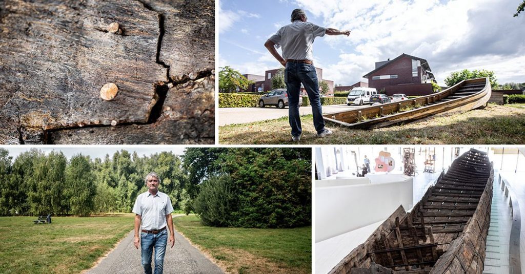
There is a tree on a meadow in the new residential area of Vleuten-De Meern. “Alder is black,” says archaeologist Eric Grafstal. But in his mind he sees something else. “There must be a swamp Roman bridge below.” He points to a football field in front. “There was a breach of the Rhine around AD 120, leaving a rift, and an overflowing channel.” He walks along the pond at Lawick van Pabstlaan, spreading his arms. “This is where the shoreline extends.” Pointing to the north. “This is where the river flows, at least a hundred yards wide.”
When a Graafstal drives, bikes or walks in Leidsche Rijn, he always sees a place where he and his colleagues from Erfgoed Utrecht excavated parts of Limes, the northern Roman Empire, between 1997 and 2019. The discoveries have provided – ship remains, enclosures, bridges, piers , roads, watchtowers, jetties – a unique picture of how the Romans managed to survive in a river landscape for three or four centuries.
The tour of Roman water management venues began at the Hoge Woerd Museum, which was built on the remains of a Roman fort discovered in 1940. In the museum’s café, Graafstal pointed to a column. It stands on the site of a small excavation from 2015 that showed well the water forces that the Romans had to deal with. “We first find clean remains from the late 1st century AD, followed by the fire layer from 69, when the Batavian erupted. But underneath there were no remains expected from 40 to 41, when the first fort was built, but two thick layers of sand.” Investigation revealed that it was sediment from two massive floods. The solution against more floods was simple: since then, when rebuilding castles, which they always built near the river for strategic and practical reasons, the Romans first brought a good layer of soil to serve as a mound.
In Lawick van Pabstlaan, a footpath diagonally cuts through an apartment building. It indicates the place where the Limesweg ran, along which the Romans could quickly move troops. Excavations at this site also told us about the strength of the river, Graafstal explains. In the year 125, during the reign of Emperor Hadrian, the Romans carried out road works to repair the damage caused by the Rhine. There was a breach here about two hundred meters long.”
Over time, and judiciously by trial and error, the Romans realized that sometimes it was best to give a water room. “In the case of the fissures, they will not lead the way again over a dam that has closed the overflow channel, to sturdy bridges, a kind of swamp bridge.”
Every year the bend moves a meter to the west
Eric Gravestal Archaeologist
Throughout the area are countless fissures. So far, Graafstal and his colleagues have excavated two bridges and located two more. “There must have been at least dozens in the western Netherlands,” he says. He noticed that many new grooves were created at the beginning of the era. “Shortly after the Roman general Drusus built a dam at the junction of the Rhine and Wallis. As an unintended effect, this could have led to all sorts of breaches at Leidsche Rijn.”
About five hundred meters to the east, in Claudiuslan, there is a steel plate marking the place where the watchtower was excavated. A former watchtower stood thirty meters to the east, Grafstal says. “The river was always moving. Every year the bend moved a meter to the west. To keep a good view of the curve, the Romans moved the watchtower after about thirty years.”
Read about the behavior of rivers: meandering rivers? This is nothing for the Netherlands
corrosion prevention
At what is now Augustusweg and Trajanushof, archaeologists have come across significant erosion prevention work at the bend. In the year 100, under the leadership of Trajan, they reinforced the bank with basalt blocks and built a short dam. This groin had to make sure that the river was no longer eroded. The basalt blocks came near Bonn, about 250 kilometers upstream. This must have been many movements of the ships.” This effort apparently was not enough, because during the 2005 excavations he became famous for british tv show time team ShareArchaeologists in Utrecht have discovered the wreck of a Roman cargo ship near Groyne. The ship was high on the bank with the bow or stern of the ship and was filled with basalt blocks. It was likely that it was deliberately submerged and weighed down with basalt blocks to break the flow further.”
A replica of the ship partially protrudes from the ground next to the excavation site. “We haven’t excavated the entire ship, which must be about four meters wide and 27 meters long,” Grafstal explains. “Most of it is still in the ground.”
This draws attention to another aspect of archeology and water: the water level in the area must be high enough to prevent the wood from coming into contact with oxygen and drying out. “After the excavation, the Dutch Cultural Heritage Agency pushed the observation wells into the ground to measure and monitor the storage conditions,” says Graafstal. He looked around for a while, but couldn’t find any observation wells. Perhaps they stopped observing when they saw that everything was fine. I know the level of locks in the area is being monitored, and it’s still fine. We recently found antique wood nearby and it was in excellent condition even on the top tier. So the ship will be fine, too.”

“Total coffee specialist. Hardcore reader. Incurable music scholar. Web guru. Freelance troublemaker. Problem solver. Travel trailblazer.”


More Stories
GALA lacks a chapter on e-health
Weird beer can taste really good.
Planets contain much more water than previously thought