

/s3/static.nrc.nl/wp-content/uploads/2024/04/26152545/data114819028-6ce62a.jpg)


The infrastructure of the Crisis and Disaster Team (CIR) and the Suriname Meteorological Service (MDS) of the Ministry of Public Works (OW) is preparing for the upcoming natural disasters. There is ample reason to warn society of the violent storms expected soon. This can also be accompanied by heavy rain.
That’s why OW continues to keep the community informed by providing everyone with the right information at the right time. Research and measurements have shown that the Intertropical Convergence Zone (ITCZ) is currently located over Suriname, which will be partly activated regularly by longitudinal wave perturbations and pulsations of low pressure zones.
The period from May to September is characterized by the elongation of tropical waves (from the west coast of Africa). Tropical waves and hurricanes are expected to be very active this year, due to the high seas already recorded in the tropical Atlantic Ocean, the Gulf of Mexico and the Caribbean Sea.
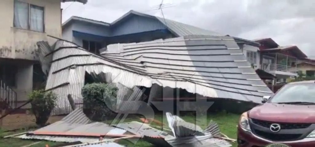
It can be very dry and warm at times, but the frequency of thunderstorms will continue to increase until August of this year. Such showers can be accompanied by occasional short-lived gusts of wind, after which storms can also develop in favorable climatic conditions. Hurricane season begins in June and ends in November. Depending on the location and displacement of the cyclones, Suriname can be affected by the spiral band, which is accompanied by torrential rains and storms, the wind speed of which can exceed 70 km per hour.
It is further indicated that storms develop around rain, and they can strike suddenly and change the direction of the winds, but true severe storms occur during thunderstorms. EW authorities are also informing the local community that during a thunderstorm, local temperatures can drop as low as 10 degrees. Such a situation is referred to as subsidence, since strong wind speeds are measured, associated with heavy precipitation.
We in Suriname know this as Sibusi. These whirlwinds also occur in Suriname during this period. It is a tornado visible under a thundercloud as a funnel-shaped trunk. Hurricanes also cause a lot of damage to buildings and trees. Since the wind direction or wind speed changes with altitude, this causes the storm cloud to rotate and the cloud can start to rotate. When this rotating column of air is sucked up by upward motions (turbulence) in the cloud, a rotation about a vertical axis is created. When the funnel reaches the ground, a tornado or whirlwind is born.
It is important to know that trees near homes and roads can pose a danger before and during inclement weather. Suriname is currently experiencing a lot of rain, which completely saturates the soil. As a result, the grip of trees is reduced and they can fall more quickly.
“Check the trees in your area for old wood or tall branches growing near your home and trim them as needed. Check for loose zinc panels and clean the gutters each year.” In the past ten years, we have had to deal with the increasing frequency of natural disasters.
So it is recommended to get insurance against storms and natural disasters. Never hide under a tree in high winds, branches may break and trees can be uprooted. Stay indoors during a storm and only go out when absolutely necessary.
It is recommended to drive mainly on main roads and avoid tree-lined roads. It is also advised not to park cars under trees. If you need help after a storm, you can contact the NCCR at 114 or the Public Works Infrastructure and Disaster Management Team on call or app number 8989114.

“Total coffee specialist. Hardcore reader. Incurable music scholar. Web guru. Freelance troublemaker. Problem solver. Travel trailblazer.”
More Stories
The poorer the neighborhood, the fewer the number of vaccinations
Outgoing museum director Andreas Blom remains loyal to Groningen and is wary of floundering. “You must give space to my successor.”
Not only are these beautiful moths resistant to highly toxic plants, but they also use the poison to seduce their mate