


Strong winter weather is currently affecting large parts of northeastern and central Europe. Around the Black Sea and Crimea, Storm Bettina is currently causing a real blizzard with continuous heavy snowfall and strong winds. Europe will remain under the influence of winter’s strong blow in the coming days. But where does this winter weather suddenly come from? How cold is it exactly here? Can we expect snow too? Meteorologist Samuel Helsen explains.
Where does sudden winter weather come from?
Winter has arrived early this year, and we owe it in part to the recent fall weather. Autumn is traditionally a period when temperature contrasts between north and south increase sharply. A cold reservoir is accumulating near and around the North Pole, while temperatures in the south remain high. These temperature discrepancies have led to pure fall weather in recent months, often with rain, wind and even stormy weather on a regular basis.
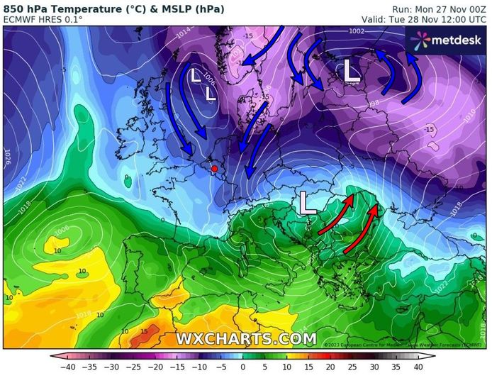
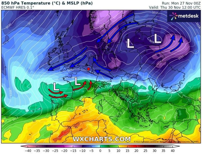
The fall episode now opens the door to winter weather across much of the European continent. The cold reservoir near the Arctic moved south and expanded into Scandinavia and Eastern Europe. In this way, the weather in large parts of central and northeastern Europe is currently determined by the supply of cold polar air. This cold air is trapped beneath a complex low pressure area that currently lies over central and northeastern Europe.
Read more below the picture
This type of cold air will also remain confined over Europe next week, leading to wintry weather. The weather is also quite cloudy at the moment. A high pressure area has developed over the Atlantic Ocean and near Greenland. This high-pressure area creates a blockage, so to speak, so that Atlantic turbulence loaded with fine sea air has little chance of penetrating the ocean into our region. This way, the cold air currently over Eastern Europe has the opportunity to expand further, opening the door to winter weather.
Various depression cores rotate in the complex low-pressure area. In recent days, a strong depression has developed near the Black Sea and Crimea. The low pressure area even developed into a real storm called “Bettina.” The combination of a strong wind field and an outbreak of extremely cold polar air created extreme conditions with unprecedented intense snowstorms and storm surge in Ukraine and parts of the Crimean Peninsula. Wind speeds on Sunday peaked at 140 km/h. In the coming days, the storm will gradually weaken and move northward, so it seems that the worst is over.
look. ‘Worst storm of the century’: Russian trenches in Crimea ‘swept away by Storm Bettina’
Will it remain this cold in Europe in the coming days?
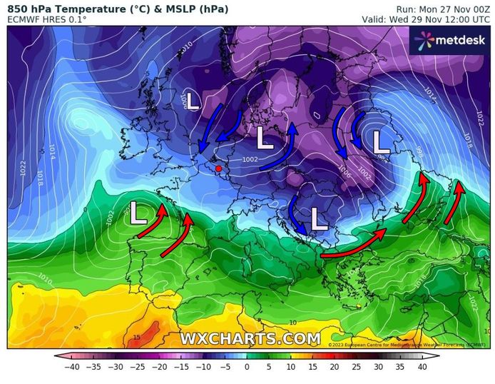
The cold will spread further across Europe in the following days. Scandinavian countries in particular will have to deal with a very cold air mass. Today and tomorrow temperatures at an altitude of 1.5 km will reach about -20 degrees Celsius. It will also continue to freeze at the surface, with freezing temperatures overnight.
Large parts of central and eastern Europe will have to deal with freezing weather, even in Germany. It was already snowing there, just as it had been with us in the Ardennes.
What does it bring us back? Are we still expecting snow?
It will also be colder here in the coming days. On Monday evening, a depression core will pass over our country with temporarily softer air. As a result, we still have to deal with the rain. The air will also become cooler in the Ardennes, meaning precipitation could temporarily turn to rain or melt snow.
Read more below the picture
Behind the heart of the depression, cold air will flow from the north to the northeast on Monday and Tuesday night. This is how we also end up in cold polar air. Tuesday will be mostly dry with sunshine. The mercury then rises to about 5 degrees during the day, and during the night temperatures are near or just below the freezing point.
Another area of low pressure and showers will pass through on Wednesday. This could be rain showers, melting snow, or some hail. The upper air cools slightly, which can give the precipitation a wintry feel. Especially in the morning, evening and night hours, rain can fall in the form of melting snow or even temporarily in the form of snow. During the day it is very mild in Flanders and there is rain, hail or melting snow. In the Ardennes region, rain falls as snow anyway.
Read more below the picture
How long will it stay cold?
Starting Thursday, uncertainty will increase on weather maps. We may be stuck in cold air with temperatures barely rising above freezing during the day and general nighttime frost. Then the low pressure area will pass south with drier weather. But this scenario still needs to be confirmed in the coming days.
The course of depression will be crucial. In recent days, this has been calculated further north with a lot of snow falling over the Netherlands and rain in our country. The core of the depression over France is now being calculated, and it will remain dry according to the European weather model. Some weather models calculate snow along the border with France. So obviously the cards haven’t been shuffled yet, but it’s definitely exciting.
Read more below the picture
What will happen next is still very uncertain. All options are still open. It will also depend greatly on the air mass that will be able to reach our country. Then the boundary between the cold air from the northeast and the soft air from the southwest will be somewhere near us. Small shifts in weather maps will mean a world of difference.
This uncertainty is clearly reflected in the temperature column. In this graph we see about fifty possibilities for how our temperature will develop over the next 14 days. We clearly see that the weather will be colder in the coming days with night frosts. But we also see that uncertainty increases sharply starting and especially after the weekend. After all, the different calculations of possible temperatures are very different.
Read more below the picture
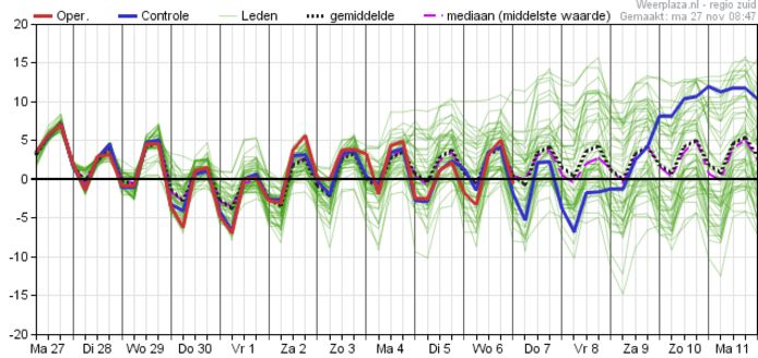
There is a fairly good chance that the winter weather will continue for a while, with slightly positive temperatures around 5 degrees during the day and frost at night. At the same time, we see that some options show temperatures of 10 degrees Celsius or more. This is the difference between a persistent cold polar air mass or milder marine air from over the ocean.
Why do you sometimes scratch your car window when it’s not frozen? How do you prevent this?
Not US advice but ‘temperature inversion’ helped Ukrainian forces sink Russian ship: Meteorologist explains weather phenomenon (+)
You can also see this rare bird in our country during the winter: “This owl is often active during the day.”
Free unlimited access to Showbytes? Which can!
Log in or create an account and never miss a thing from the stars.

“Creator. Award-winning problem solver. Music evangelist. Incurable introvert.”
More Stories
Repercussions and scenarios after the possible resignation of Prime Minister Pedro Sanchez in Spain
The United States is accelerating military aid to Ukraine, while Russia is trying to stop it as much as possible
King's Day: 10x facts and figures