


The European Commission has a new a map Which presents the risks of forest fires in Europe in a uniform way. “Since many wildfires cross national borders, it is important to have a standardized approach at the European level,” says Jan Paitens, Professor of Mathematical Modeling of Natural Processes at the University of Ghent.
Why is a European wildfire risk map necessary?
Jan Baetens: First, because the frequency of extreme weather events is expected to increase. Heat and drought are associated with increased fire risk. Second, because not all EU member states have already identified bushfire risks, such as Belgium, and because sometimes the approach varies greatly between countries that have already done so.
It was long believed that forest fires were a thing for Mediterranean countries like Spain, Portugal and Italy, but nowadays you also have it in northern countries. It is important to have a unified approach at the European level so that the risks are understood in the same way everywhere. Now that the analysis has been carried out at the European level, each member state can adopt the methodology and apply it at the national level.
How did this map appear?
Bitenes: The European map was developed by the European Commission’s Joint Research Center (JRC) and a group of forest fire experts from 43 countries, both EU member states and neighboring countries. From this position, she has played an advisory role in map development for the past two years.
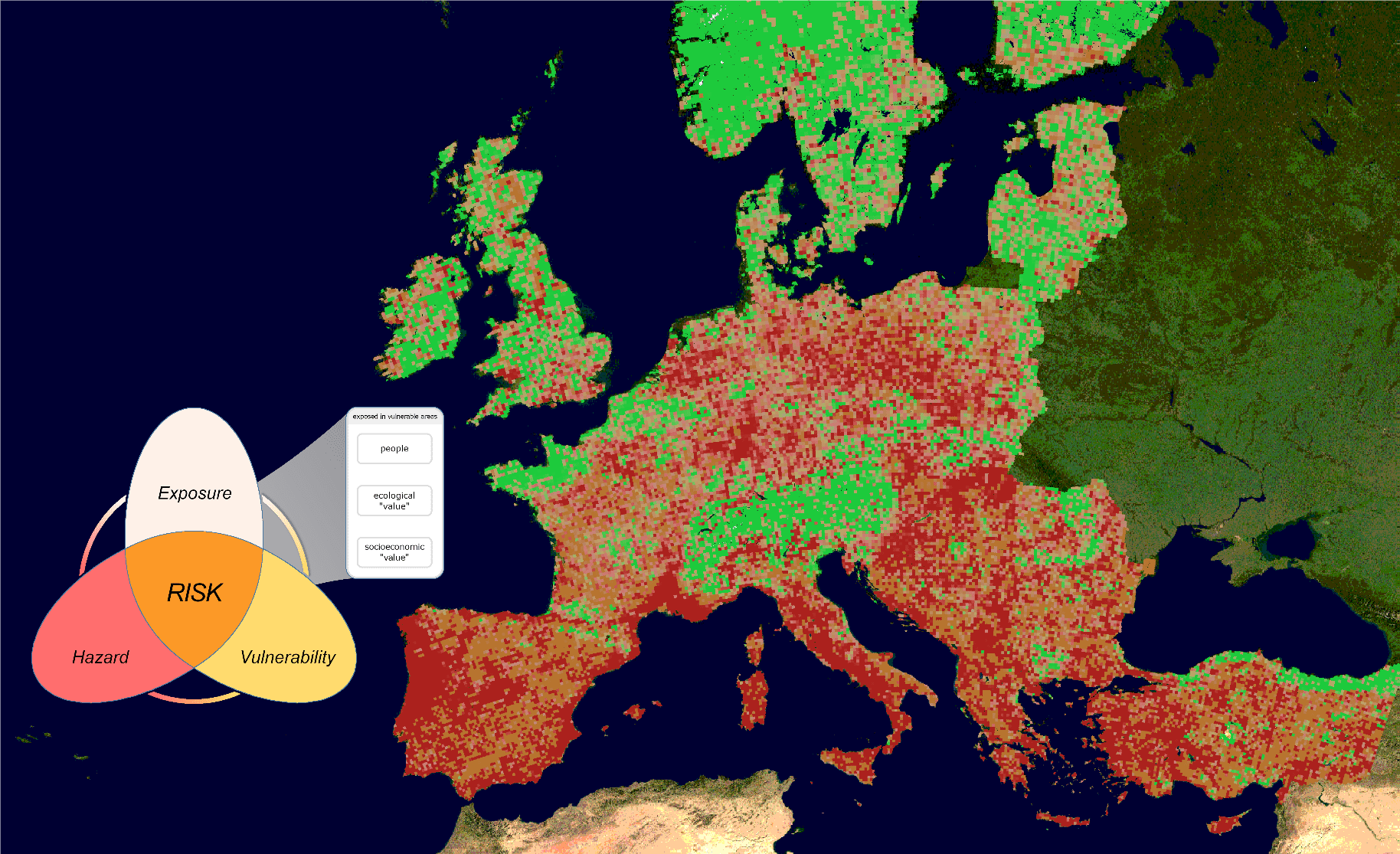
As experts, we first drafted a definition of “forest fire hazard”. For this we considered three aspects: risk, exposure, and vulnerability. Things like vegetation, temperature and humidity have an effect on the hazard. These items can cause a fire and its spread. In addition, we also looked at the damage a potential fire can cause to ecosystems, people, and businesses. These elements affect vulnerability and exposure. When all the quantitative data on these aspects are gathered together, the risk of wildfires can be determined. Methodologically, this is a huge step forward.
During warm and dry periods, this will result in a relatively low risk in urban areas and a high to very high risk in a nature reserve such as Kalmthoutse Heide. In cities, vulnerabilities and exposure due to the presence of people are high, but the chance of spread is almost non-existent. In Limburg Kempen, the risk of fire and the risk of spread is relatively high due to the presence of a lot of vegetation and sometimes litter as well, and the relatively dry sandy soil. Moreover, the nature reserve is surrounded by people and businesses, so vulnerability and exposure also score high.
Are wildfires moving more and more north?
Paytnes: In recent years, we’ve seen wildfires in unexpected areas. Fires broke out in Scandinavia, Ireland, the Netherlands, northern Germany and the United Kingdom. Ten or even five years ago, it was definitely not a priority there.
Do we need to adjust our preventive approach in Belgium?
Baettens: In Belgium, we see that according to the new map, the greatest risk areas are currently in Antwerp, Limburg Kempin and Hai Venise, but also in large parts of East Flanders and Lorraine Belgian. During periods of warmth and drought, preventive measures are taken in certain areas by closing nature reserves, staffing fire towers and increasing vigilance. But there are no fire towers in the nature reserves in East Flanders, although there are high to very high fire risks in much of that province.
Since we have a temperate climate in our country, we assume that we cannot see many wildfires here at the same time. However, we are now seeing this happen in France, where forest fires are no longer occurring only in the Mediterranean, but also in the north of the country. The equipment and people needed to extinguish the fire cannot be deployed in different places at the same time.
Belgium often invites neighboring countries for air support, which can become a problem, because neighboring countries need their own equipment and want to be able to quickly deploy it on their territory. So there is a message for the government. With the increasing frequency of wildfires, we need to focus more on inventory, prevention, and equipment improvement. We are now seeing the fifth warm, dry summer in six years. So it is better to be well prepared.
Can governments really start with the new card?
Baetens: Sure, that’s one of the reasons the map is rolling out faster than expected. We’re going through a long, warm, dry period and people are starting to wonder where the danger zones are. The new map clearly shows the risk of wildfires in Europe and surrounding countries.

“Total coffee specialist. Hardcore reader. Incurable music scholar. Web guru. Freelance troublemaker. Problem solver. Travel trailblazer.”
More Stories
“Ask at least one question in return.”
Elbendamers in the Sun: What a Wonderful Little Village
European Space Agency – Space for Kids